21 March 2011

Doomsday is Today

Today we will be back on the Mainland again after four months in the Keys.  We got off to a cold start as December was the coldest month in recorded history.  However, the other months turned out to be very pleasant. 

We got in a lot of kayaking and explored some new territory.  We tried some new restaurants in the Keys and discovered some good food.  BJ fell in with a group of quilters and learned a lot about the craft she has always been interested in.  I got some diving in with some new dive buddies on some interesting reefs around Key West.  We enjoyed the camaraderie and activities in the RV park with new friends.


We started off at Long Key State Park until mid-December when we moved to NAS Key West and stayed there until early March when we moved up to John Pennykamp State Park as we prepared to start our summer travels.  We got in a good day of kayaking the Upper Keys and enjoyed the warm sunny days. 

We did visit the 2nd oldest marine park in the US, Theater of the Sea in Islamorada.  The oldest was Marine Land south of St Augustine and no longer open to the public.   And, Theater of the Sea needs to do the same.  It is long in the tooth with old facilities, weak programs and the water is ugh!  And, they have an interactive program where you can swim in the water!!  Of course the gift shop is fully stocked with high price gadgets.  If they spent as much time on keeping the facility up as they do the gift shop it might be a better place.  Not recommended by us!


We did some geocaching  and enjoyed that and are really looking forward to doing that with Reagan, especially!  It is a world wide treasure hunt where people place “treasure” and then post the GPS coordinates on line for others to discover.  The treasurer is small boxes with little trinkets inside and we can see Reagan just having a great time figuring out what she is going to trade for.  If you take something, you have to leave something of equal or greater value.  Learn more at this website!  The picture to the right shows the view from one geocaching location I went to.  The cache is on the bench where I had it to sign the log.  I returned it to its hiding place after taking the picture!!


To the left here is a pic of another cache.  Look at all the treasures inside the box.  Reagan would have a ball!


I finished off our stay with a fabulous dive weekend.  On Friday afternoon did the Duane, a Coast Guard cutter sunk as artificial reef some 20+ years ago.  It is a great dive and it was followed by a dive on Pickles Reef and Snapper Ledge, two places loaded with reef fish.  Saturday AM we did a double dip (two dives) on the Speigel Grove, I large (510 ft) former Navy ship sunk as artificial reef  in 2002.  Then Sunday AM a dive on the Eagle, another Coast Guard cutter sank has an artificial reef in the 80’s.  However, about 6 years ago it was torn in half by a hurricane.  So it makes an interesting dive, the two parts are about 20 feet apart and the interior is wide open.  The weather for all 3 days/7dives was beautiful and viz was great and there was no current on any dive.  Conch Republic Dive Shop was up to its normal great standard.  Could not have had a better dive weekend!! 
So Monday we hit the mainland and head for our first stop – Melbourne for 3 weeks or so, then on to Jax to see Garrett and my brother, before we head to Carolinas for family wedding end of Apr.  After that we will spend some time on the road visiting DC and other points of interest arriving in Newport RI where Reagan and Addison and their handlers are.  After  a month there we will head West for a few years!! 
Keep in touch!!

17 March 2011

Forida Key Deer

The Florida Key Deer is one of the many interesting things making the Keys such a unique place.  They use to be found throughout the Keys wherever there was a reliable fresh water supply.  Due to habitat destruction, both man-made and natural, they are now normally found only on Big Pine Key and, very nearby, No Name Key; in the wet season they may range on to other nearby Keys temporarily because water is there.  
In the late 1940’s the total population was thought to be only 30-40 deer.  However, since then an aggressive protection program has rebuilt the herd to an estimated 700-800.  They are use to cohabiting their territory with humans and show little of the fear commonly seen in their bigger White-tail deer relatives.  
It also leads to their biggest threat – the automobile.  Especially at night, they wonder freely around the keys and invariably some are hit by autos. It is estimated that deer-vehicle collisions account for 50% to 70% of the annual mortality of Key Deer.  The speed limits on Big Pine and No-Name are strictly enforced to try and reduce this lost.  Most human inhabitants take pride in “their” deer and take precautions to control their dogs and otherwise protect the deer.  
The Key Deer is not hard to spot along the road or in the pine scrub, especially near sunrise or sunset.  They graze nonchalantly as humans go by on their errands.  When some stop (usually tourist) they will sometimes even approach or allow the people to approach, but usually will keep their distance.  It is illegal to feed or bother the Key Deer.
The National Key Deer Refuge was established in 1957 to help insure the survival of the deer sub-species as well as other Keys wildlife.  Its headquarters is on Big Pine Key and the refuge covers much of Big Pine Key and No-Name Key. Adult male Key Deer usually weigh 55–75 lb and stand about 30 inches tall at the shoulder. Adult females usually weigh between 44–64 lb and have an average height of 26 inches at the shoulders.  Except for size they closely resemble the common White-Tail deer found throughout the US. 

Another interesting part of the unique Florida Keys. This LINK is to an info sheet on the Key Deer.

14 March 2011

Our Migration NORTH!!

As the sun sets on our season in the Keys, we look back on a wonderful three plus months enjoying many different activities and new friends as well as some old ones from previous visits. The weather got off to a bad start in December which turned out to be the coldest Dec on record.  It was rainy and windy and cold all at once!

However, Jan and Feb turned out to be beautiful weather interspersed with a few cool and/or windy days that gave us a break from kayaking and fishing!   We kayaked to some new Keys and revisited some we had visited on previous trips.  We, also worked on a new activity we have become involved in geocaching and are looking forward to that treasure hunting fun with our granddaughters.

This year we will visit our granddaughters and their handlers in RI before heading west to see Yellowstone National Park and the Grand Canyon as well as many other sites out west.  We plan on overwintering in warm weather,probably in SW Arizona at least part of the winter.  There is a huge RV gathering there in Jan and we will be there for that.

In Summer of 2012 we plan on doing Alaska in the RV and after that start working our way back to FL and hope to spend winter of 2012-2013 back in the Keys!

About mid-March we will start our northward migration but will do it slowly to mitigate any shock from the cooler weather.  We will move to the Upper Keys for about a week to start the acclimation process for colder weather.  About a week later we will move to South Fl and the Everglades National Park to help us get our land legs back after being on the keys which are very "fluid"!   After that we will return to Melbourne to visit family and do some routine appointments for about 3 weeks.  Hopefully we will survive the chilly Apr temps there and toughen up for the next jump north.  We will go to Jax to visit our son and my brother and after that go to NC to visit BJ's family and attend a niece's wedding at end of April.  We will then move on toward RI and arrive there about end of May for a months stay before heading west!

Stay tuned for more of our story!

10 March 2011

Treasure Hunting in the Keys

BJ and I got into geocaching which you can check out by clicking on this link.  Actually, I think I am into it more then BJ but what interested us about it was doing it with Reagan and Addie, especially Reagan.  Most of the cache's have trinkets included that you can trade with trinkets you bring - rule is don't take anything if you don't leave something!!  There are hundreds of thousands, if not millions, of cache's worldwide.  At the website after you have registered (free) and agreed to abide by the rules you can get the GPS coordinates of caches where ever you are or are going to be!  We have found several dozen in and near Key West.
While BJ was working on here quilt the other day I decided to go up to Big Pine Key and do some treasure hunting for caches there; also was expecting to see some of the Key Deer!  I downloaded about 8 caches to the GPS, already had some along the route there downloaded, and headed out about 1PM.

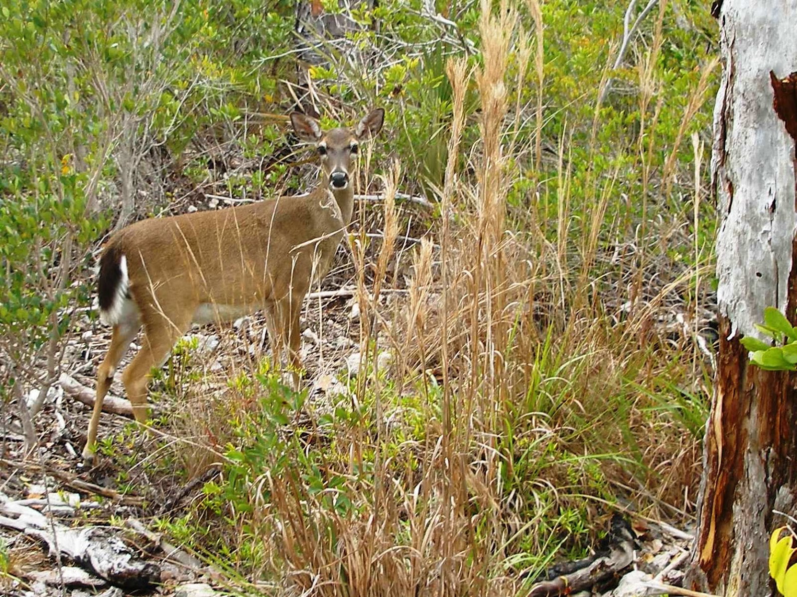
First two were right on the edge of the Keys Deer refuge and I found the caches fairly quickly; one was in the hallow of a dead tree and the other was buried under some rocks at the foot of a phone pole, but no Key Deer.   I next headed to No-Name Key which is connected to Big Pine by a bridge near the No-Name Key Pub - a traditional watering hole in Big Pine!!  In this case there were two different caches in back country away from the main road across No-Name.  It is prime territory for the Key Deer.   I parked off the road near a path leading into the wilderness and headed down the path.  First think to greet me was a Key Deer.  She backed off the trail a little, but did not run or show fear.  Just watched me go by as I continued along the minimal path.

Shortly however, the path became even more minimal to virtually non-existent.  I was making my way thru the woods headed in the direction my GPS was pointing.

I was surprised to run across a very rusted out auto frame; no engine, no body parts, just a frame with a bright chrome bumper attached to it.  Not enough for me to tell the vintage of the original car, but was amazed that the chrome bumper still looked so good - they don't make'em like that anymore!!  See the pic of it I have included.  

Eventually, I broke out on a slightly more civilized (barely) trail that was going in the general direction I needed to go.  I continued along it thru several intersections with equally primitive trails until I came to a "road" thru some wetlands that were not wet, because this is dry season.  The road bed was raised and there were culverts under it to facilitate the flow of water when it was there.  The road continued toward the shoreline which is where the cache was located.  Shortly, I approached the shoreline and found a break that ended up right at the foot of the dock that was my "target". 
 After finding the cache and signing the log I headed for the second cache in this area.  It was about a half way back on the trail I came in on and off to the side.  Here are some links to the two caches if you want to see what the cache webpage tells you.
No-Name Key dock  and Dirty Dog Pond on No-name Key
Note the coordinates are not shown unless you are a registered user, but all info is otherwise there including all the logs and pics entered by the geocachers that have "found" these treasures!!

After returning to the Jeep and thanking the Key Deer that had been guarding it for me, I decided I still had time to do a few more.  Both were on the main N-S road of Big Pine Key.  One was a nice little one that Reagan would have been delighted with.  It was a box full of "treasures", it would have taken all day for her to figure which one she would have traded for!!  The other one was at the Blue Hole, a pond in the Keys Wildlife refuge that is a fresh water pond.  This was a virtual cache, i.e. there was no physical cache as is normal but you have to provide the person who placed the cache with info, and sometimes a pic, to show that you were there.  I collected the info I needed took a pic of some Key Deer and alligators that were hanging around watching the tourist and went on my way.
                                                        
It was getting too late and I skipped the great temptation to stop at Sally's Ice Cream shop where they hand make the best frozen custard in the Keys!

I headed on down what is I believe one of, if not the most, beautiful drive in the World, the Overseas Highway aka US Highway #1.  One of the reasons I skipped Sally's was because I wanted to see the vista's across the islands and seas the road traverses and it would have been after dark if I had gone for the custard!
                                                                                                                                                      
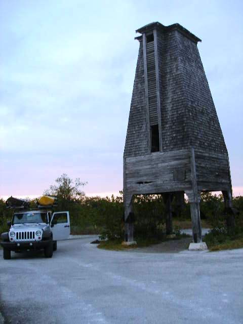
However, it was still light when I got to MM17 and I could not resist one more hunt.  There was a cache near Perky's tower which I have seen a dozen times because we frequently drop our kayaks in the water nearby.   I found the cache with minimal delay and signed the log book and moved on!  The tower was build in late 20's as the bright idea of a fine Yankee gentleman to control mosquitoes which were a real problem in the Keys in those early days.
He knew bats consumed prodigious amounts of mosquitoes so he reasoned if he built accommodations for them they would move to Sugarloaf Key where his bat motel was and make the area mosquito free!  In theory, it sounded good and he certainly did his part.  The bat tower has survived multiple hurricanes, including the 1935 killer hurricane, and stands today pretty much like he built it.  But, nobody has ever seen a bat in it!!   Meanwhile the Mosquito Control Commission has controlled the mosquitoes quite well, while unleashing one political turf battle after another!  The Executive Director is the highest paid civil servant in Monroe County!!  It is another of the many political entities that make life in the Conch Republic so interesting!

05 March 2011

A Great Day on the Water

 After I series of days that were cool and very windy, BJ and I were both glad to see the calm water and bright sun.  We had been talking about a serious kayak day as soon as the weather turned better and finally the day was here.  I was especially anxious to try out my new kayak I just got – a Native Watercraft brand Manta Ray 14, bright yellow so it could be seen easily on the water!!

We decided to do a trip around No-Name Key which is just NE of Big Pine Key, about 30 miles up US 1 from Key West.  It had been several years since we have kayaked in that area and we were glad to have the chance to explore it again.   We loaded up the kayaks on the Jeep and headed toward No-Name Key.  We noted on the way that the tide was really low, but thought water around No-Name was going to be deep enough.   

We got to the launch point on No-Name and there were three other couples there and preparing to leave as the tide was too low to comfortably launch the kayaks.  It would have been a very messy, muddy, difficult launch and it was still several hours before tide would turn.  After short discussion we were invited to join them as they headed for another launch point on Big Pine Key. 

We got to the new launch point and it was great, a boat launch that would have been difficult for a boat trailer but was perfect for launching kayaks.  There were several keys in the distance so we all headed off; however, after about 20 minutes we parted with them and headed to a key a little further out then they wanted to venture.
 
We shortly ran into some very shallow grass flats that had the kayaks rubbing the bottom but eventually got to Annette Key and it was beautiful.  We went on the outside of the key (north side) and the water was clear and calm.  It was like we were gliding through the air looking down on grassy fields and the fish were little birds flying below us!  The key was about a mile and a half long and we enjoyed it all the way.  At the end we were undecided if we should move on to the next key (Cutoe Key) or head toward our launch point so we stopped and had lunch and shared a beer!


Eventually, we decided to save Cutoe Key for another day and continue on around Annette Key and back toward the launch point.  Sun was bright and day remained calm and we really enjoyed the trip back via a different, but equally beautiful route.  We saw beautiful grass beds in the crystal clear water.  Fish of various sizes and shapes would dart across the sand patches we glided over from time to time.   By the time we returned to the launch point the other couples were long gone.

 We had been gone for 4.5 hours and kayaked about 8.5 miles total.   As we were loading the kayaks on the Jeep a key deer came out of the woods to drink some fresh water from a puddle in the road.  He was aware of us and kept and eye on us, but we did not seem to bother him too much.   He was still alongside the road grazing as we drove off after another wonderful day on the water in the Florida Keys!

02 March 2011

Tarpon Belly Key and Beyond


Sawyer and Rider Keys are right on the edge of the Gulf of Mexico north of Cudjoe Key which is on the Overseas Highway, aka US Highway #1, the Main Street of the Florida Keys.   There is supposed to be some pretty sights there including lots of birds some beach and it is a generally nice, if not long paddle at about 6-7 miles one way.  Wind and tide can make it challenging because there is a cross key channel from the Atlantic to the Gulf under Niles Bridge that goes out to Sawyer and the tide in particular can make it seem a lot further, or conversely a lot shorter.

Also, on Tarpon Belly Key was a geocache I wanted to find. 

BJ was less than enthusiastic about the  10+ mile round trip due to possibility of changing weather conditions and impact of tides so I had been discussing it with other kayakrs and Jerry and Harold and I decided Monday was a good day.  Winds were forecast to be 10-15 in the AM from the SE but were expected to calm down to less than 10 in the afternoon.  Tide was supposed to be high about noon and the receding tide would be to our benefit on the return trip when the wind would be minimal according to plans.  We planned on stopping at Tarpon Belly Key on the way out and maybe on the way back.
Tarpon Belly Key geocac
Launch point was end of Blimp Road near the US Air Force base about 2 miles north of the Overseas Highway and we set off from there about 0930 with the 10-15 mph wind at our back.  We made it out to Tarpon Belly Key in about an hour.  Jerry and Harold set about exploring the key while I focused on finding the geocache.
Tarpon Belly Key camping with shower in background!
 About a half-hour later I set off to find them which I did in about 10 minutes.  They were on the south side of the e-w channel.  It appeared to be a popular lay over for visitors.  There was several fire pits along the shore and some abandoned “furniture” and at one spot someone had left a thermal shower bag hanging in a tree.    
Over lunch we enjoyed on a nice rug someone had left on the rocky beach we decided the wind had not subsided and may have become stronger!  We were only about 1/3 of the way to Sawyer and with the strong wind the trip back would be more then we bargained for.  So we decided to head for Raccoon  Key which was southeast of the Tarpon Belly so we would be going across the wind to and from that key and would stop a Budd Key to look at an interesting place there.  

Raccoon Key side trip
Raccoon Key was at one point in the past used by a US company to raise monkeys for research labs.  But, they are all supposed to be gone by now and we saw no sign of them.  I took a short trail into the key but found nothing interesting.  We also kayaked into some mangrove creeks but they all were loops that were nice side trips.   

 The trip from Raccoon Key to Budd Key was on a southwest course so we were still going across the wind to some degree vs. directly into it and we were still heading back south to the launch point!   Budd Keys are two separate adjacent keys with very skinny water between them.  Jerry had discovered on Google Earth that there was a path to an interior pond on one of the Keys and we wanted to explore it!
There were some pilings at the landing indicated a dock had existed there at one point in time!  We walked about 200 feet to the interior and found the pond.  It was clear and clean water but no discernible fish life.  Its level is about 3 feet below the rocky surface of the key.  As we walked around the pond we first saw the remnants of an old house trailer.  Without the trailer frame there it would have looked like a pile of tin sheets thoroughly rusted!  As we continued around the pond we encountered a very rusted car.  
Car parking on Budd Key!
We believe it was an old Lincoln based on the minimal grill and one fender remaining.  The carburetor was laying on the engine and the valve covers were long gone!!  Further on we found what must have been the homestead but it was no more then a pile of metal, wood and brick mainly grown over and on the other side was another car, even more deteriorated then the first one we saw!!  It was interesting to see the car hulks there as there is no indication there was ever a bridge to the key and it was not big enough to drive on with or without a road.

We returned to the kayaks and headed out on the last leg of our trip.  It was one mile to launch point and even though we were heading into the wind and it was still strong, by now we were use to it.   We enjoyed a beer and loaded the kayaks and headed back to Key West.  Along the way, I looked for and found another geocache near Baby’s Coffee on Sugarloaf Key.

The yellow route is our actual route and the red one was the planned one!!