29 October 2012

Dancing with Sandy

Well we have found a few leaks this AM, but nothing too bad!  Have not lost power but genset is ready if we do.  High tide was about 0830 and I have some pics I will include but it was no threat at all to us.  Highest winds are supposed to be late afternoon/early evening then it starts to get better; if you see the Eastern Shore mentioned with dire consequences they are talking about the northern part, not where we are on the southern tip.  We are nearly 100 mi south of there and they are that much closer to the center of Sandy.  They are projecting hurricane force winds near  Chincoteague and we are told gusts to 50 maybe.  They have quit giving updates on the SW portion of Hampton Roads as it is out of the action and starting to return to normal and that is the route out for me & the Gray Ghost in the AM as we head to FL for my BIL's funeral. 

However, my brother advises me it is going to be 37 degrees – what the hell is that about!


Kayak launch yesterday at low tide, except this is where water level is normally at high tide.  Some extra water due to Sandy.


This is the road to/from the kayak launch when the pic to the left was taken.  You can see the edge of the parking lot for the kayak launch there in the lower left hand corner of the pic.  If you go up this road and just past the turn you can see then turn right and go about another 150 yards you will be in the RV parking area. It has 5 spots with 4 currently occupied .  It is for volunteers only and has full hook ups for each.


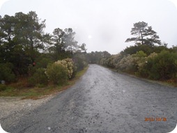
The road past the kayak launch leads to the boat launch about 200 yrs. further & it is closed due to Sandy!


This was the road to the kayak launch this AM!  The pics above were taken at the far end of the road in this pic looking down the road.  While the Grey Ghost was bucking to head down the road I reminded her I was now an old man and could not get away with such lapses in judgment that would have been routine just 35 years ago!


This is the volunteer's RV park at Eastern Shore of VA National Wildlife Refuge.


So all is well with us – we have pulled in 3 of the 4 slides mainly to protect the slide covers from getting ripped by the wind.  The only one out (DS-rear) has the smallest cover so least chance of damage.  I think they all would be fine, but best to err on the safe said!
BJ is fixing hot chocolate and my laptop is telling me to get off my tail and plug her in!  So that is all for now.
Always at home no matter where we are!

27 October 2012

Waiting on Sandy

We are buttoned up and battened down here at the tip of the Eastern Shore waiting for Hurricane Sandy to visit.   She is due in late Monday night/early Tue AM but  We seems to be on the very southern edge of her landfall and most projections are putting her even further north by the time she gets here.  This would be to our benefit.  Last year the Refuge required the volunteers to evacuate and two of those folks are here this year.  They claim they got "beaten up" worse in WV then if they stayed here!  It will not be an option if we wait too long because they close the bridge-tunnel if winds get too high and then our evacuation route would be to the north into the worsening weather for 100+ miles before we could turn west/inland. 
Of course there is always the kayaks.  We could float our way out of here! 
Kayak launch still an option!

Boat launch is closed however!

Refuge is getting lonely!

Yesterday and today has been mainly rainy and windy but that is part of the cold front moving in from the west that is supposed to meet up with Sandy for the really big party!  They are forecasting that we will be feeling the front edge of Sandy by tomorrow afternoon and then it will start mixing with front moving in from the West.  
Always at home no matter where we are!

11 October 2012

Eastern Shore of Virginia

The Eastern Shore of VA (ESV) is on the Delmarva peninsula and extends from the northern end of the Chesapeake Bay south to the mouth of the Chesapeake Bay.  Delaware, Maryland, & Virginia each have part of the Delmarva  peninsula and the VA part extends south from the Maryland line which is just north of Chincoteague Island, home of the famous ponies.  We are 75 miles south of there at the very southern tip of the ESV where the northern end of the Chesapeake-Bay Bridge Tunnel lands on the ESV. The bridge-tunnel complex crosses the mouth of the Chesapeake Bay and is a 22 mile long bridge, tunnel complex connecting Norfolk to the Eastern Shore.
Welcome!

We are volunteering at the National Wildlife Refuge until early December.  We are responsible for operating the Visitors Center Tuesday, Wednesday and Thursday.   The refuge's mission is to maintain safe habitat for  birds, especially during migration season!   Also, the Mexico bound Monarch butterflies come through about this time each year and they and the migrating songbirds that have been arriving the last few weeks hang out here waiting for favorable winds to help them make the leap across the mouth of the Chesapeake Bay.
Surveying the area

One of the residents of the NWR!

An early Monarch


BJ is going nuts with all the birding she is doing.  In addition to several Bald Eagles, there are several types of hawks and dozens of kinds of songbirds.  She is trying to know them all.  Also, since we are at the tip of a peninsula there is plenty of kayaking opportunities around!

Kayak view of the Chesapeake Bay Bridge Tunnel!

BJ on Smith Island stalking some baitfish!


This is a historic part of our country.  The courthouse in Eastville, the county seat, was an old building when the Declaration of Independence was read to the residents 5 days after it was signed!   County records  have been maintained in the courthouse continuously since 1632!  However, nearby there is a modern courthouse with most offices in it!
The original Northhampton County Courthouse built in 1631! And still a storage facility for county records! 

Historic Cape Charles is about 10 miles north of the NWR and is a quaint little town now but 100 years ago it was a bustling railroad town. In the late 19th century a railroad was built from New York city, through Philadelphia to Cape Charles.  There the rail cars were loaded on barges, a dozen to the barge, and moved to Norfolk.  This was a quicker route then the inland route around Washington DC and for until after WW II it was heavily used.  800 rail cars a day were shuffled through Cape Charles.  Today maybe a few each month! More about this nice little town in a later post.

Always at home, no matter where we are!!

10 October 2012

Coon Dog Cemetery

While in NW Alabama in August we saw a number of interesting things.  One day while riding down a rural road going from nowhere to somewhere we saw an interesting road side sign pointing to the next right turn.  It sounded interesting, so right we went!  About 6 miles down the road we found the Coon Dog Cemetery.
It was an unadorned, but well maintained sign along side the road.  We entered the woods and found many coon dog graves in the area.  Most were carefully tended with headstones ranging from the plain to the ornate!
      
                                                                                   
One of the monuments!
One of many graves.
              
      
Another monument
The history and rules


This is now a county facility.


The grave of faithful hunting companion!


Always at home no matter where we are!

01 October 2012

It is about time

I updated the blog with some current info.  We have been at the Eastern Shore of VA National Wildlife Refuge since right after Labor Day.  We are volunteering here until early Dec and loving it.  Great kayaking, friendly people and the granddaughters just across the Chesapeake Bay Bridge Tunnel in Norfolk.  We are close enough to spoil them, but not close enough to be responsible!
As mentioned in the previous entry we were tired of the cold weather in OR & WA and wanted to join our fellow citizens in the heat wave that was burning up the rest of the country!  So on 12 July at 1721 hr. in Coos Bay OR with the cold Pacific Ocean on the DS we turned EAST for the first time since leaving the FL Keys at 1015 hrs. on 14 Mar 2011.  We had enjoyed our Western Tour and extremely glad we did it but we were homesick for the Atlantic Seaboard we both finally realized.  We will be back out West!  We loved our trip and will use the info to plan our next one probably in 2014 for just 12 months or so!  We are looking forward to spending some more time in fewer selected places on that trip.  But, it will take us a year plus to winnow that list of "selected places" down to a manageable size!  But, time we have. 
Tucson on the road!

A real refrigerator! 

Stacked washer & dryer!
Another thing we both agree on is we remain happy with the unexpected upgrade in our accommodations!  Lucy, our 2003 Holiday Rambler, was an able and wonderful travel companion.  She served us faithfully for 6 years to the day but BJ's continuously growing rock hounding collection was beginning to sway her back and we felt we needed more capacity, plus we discovered we would like a few more amenities! So our upgraded RV, Tucson, is a 2009 Tiffin Phaeton with 4 slides and 42 ft. long.
Inside!
 Amenities include a stacked washer and dryer,  a real residential refrigerator, a dishwasher, and a 10 KW generator if needed!  We are much more comfortable in our new "house"!  Its GVWR is 42,000 pounds vs. Lucy's 32,000 pounds and BJ is working on filling her spacious basement up with more rocks, except here back on the Eastern Seaboard she has dramatically changed her collection direction, more seashells then boulders for her to chose from!  But, when we return back to the West she will resume the boulder collection, I am sure!
First thing we did after turning EAST was to stop in Grants Pass OR to visit our AF friends from our days at Mather AFB, Jim and Judy.  What a great time we had with them.   They took us down to CA for a day and we walked thru the giant Redwood forest.  How spectacular those giants were!  And, we took another day to visit Crater Lake National Park.  Part of the boundary road around the lake was still closed because of snow – and that was mid- July!  The lake was beautiful and clear and all I could think about was diving in it, which is allowed!  But, you had to manually haul your gear down a footpath to the lakes edge.  That footpath was a steep 750 ft. drop from the rim to the lake shore!  I did not relish bringing my 65-70 pounds of scuba gear back up the that path which the park service did not allow any wheeled carts on!  Of course the 45-50 degree water was also somewhat of a deterrent!  But, maybe next time....!
Dry, warm western Oregon on the way EAST!
BJ & Allie at Red Rock Center near Denver!

We left Jim and Judy and continued EAST across western OR where it was high and dry and warm, approaching hot!  We were headed to Denver for a visit with our niece, Allie and her family.  We had not seen them in 8 years or so!  What a joy it was to see Allie and Schyler and their two boys, Benton and Karsten!
 We had a wonderful time that passed all to quickly!  Benton is interested in scuba so maybe we can entice him to visit us in the Keys and maybe bring the whole family!  We hope so!
Restaurant in Castle Rock- good food  with great friends! 
On our last day we enjoyed lunch with Bill and Susan from Colorado Springs.  We met at Castle Rock which is between C Springs and Denver at a former church that is now a restaurant,   

From Denver we pressed on EAST, dropping down from I-70 in Kansas to I-40 in Oklahoma!  Stayed a few days at Foss Lake State park west of OK City.  Water level was pretty low and many people were concerned about the continuing drought!  And, we were out in the boondocks.
 
While there we decided to head to Red Bay AL, the home of Tiffin Motor coach and Tucson's birthplace.  I had thought Red Bay was in south AL, but found it was in far (remote) NW AL, not that far south of I-40.  We had a continuing problem with our satellite TV system and figured they could service that and a few other items we had on a short list.
One side of the Tiffin Service facility!

 We didn't have an appointment and none was available so we just showed up.  We ended up spending 18 days there and they worked on Tucson 4 of those days.  But, we had to be there each day in case we got called to a service bay!  They replaced the entire satellite TV system and did two factory recalls we did not know about and several less significant items. but we left with Tucson in top notch condition!
While in Red Bay we did take an afternoon and drive over to Tupelo MS, about 40 miles, for some shopping and so BJ could see Elvis' birthplace!  It was an interesting day!   And that led to us leaving Red Bay and heading west (temporarily) back to Memphis so she could visit Graceland!  I agreed to this because I wanted some good Memphis ribs and she did too.  We were headed to the Rendezvous Restaurant in downtown Memphis after visiting Graceland when the GPS gave us a wrong turn to Payne's Ribs.  It was a "plain" little family restaurant with minimal seating but boy were the ribs good!  At any rate after we enjoyed the ribs we headed back to Tucson, who was patiently waiting for us in a Pilot Truck Stop on the east side of Memphis and continued on EAST along I-40.
Our good friends, Frank and Maggie drove up to Cookeville TN (east of Nashville) and we had a great lunch and visit with them then headed on EAST again.  We were planning on spending a few days in Waynesville, NC but decided to continue on as we could feel Reagan and Addison tugging on our hearts and were getting more anxious to see them as each hour passed!  We did stop in NC briefly to visit with Frank & Maggie's daughter, Kirsten and her three wonderful little ones!  Weston was a work so we missed him, but next time...!
We finally arrived in Norfolk and pulled into Naval Amphibious Base Little Creek (recently renamed to Joint Expeditionary Base Little Creek) and settled into spot 35 in the Famcamp.

Reagan & Addison
 We were only a few blocks from the water's edge and at the mouth of the Chesapeake Bay where it empties into the Atlantic Ocean.  While it is not the FL Keys it is the Atlantic Seaboard and we were at last ready to rest and start stuffing real seafood down!  Which we did as soon as we say the girls, Reagan and Addison have grown so much since we saw them last! Reagan enters kindergarten this year and Addison moves up to pre-school!  We feel fortunate to be with them at this change in their lives.  More about them in later posts.
So after 10 days there we moved across the Chesapeake Bay Bridge Tunnel, a 20 mile bridge with two tunnels, each a mile long, to the Eastern Shore and we are on the very southern tip of the peninsula.  First exit off Hiway 13 after you leave the bridge-tunnel.
So that gets us up to date.  I promise posts will be shorter and more frequent now!  With more pics too!
Always at home, no matter where we are!